our operations
innovative imaging method gives clearer picture of subsurface
3 min read | june 17, 2025
Industry-leading new technology helps Chevron evaluate exploration prospects, so it can target reservoirs more accurately.
James Davenport, general manager of Geophysics and Petrophysics at Chevron (center), discusses full waveform inversion (FWI) seismic imaging of the Anchor deepwater development in the Gulf of America with Chevron exploration geophysicists Jennifer Zhang (left) and Casey Ruplinger.
An innovative technological advancement is giving Chevron a clearer picture of what lies beneath.
And in the world of exploration, more accurate imaging has a positive ripple effect.
Chevron is using this new technology so it can image the subsurface, both onshore and offshore, to identify and evaluate exploration prospects and better characterize discovered resources. For example, the technology was used to characterize the recently developed Anchor Field in the Gulf of America. It provided a clearer picture of the subsurface, which aided development planning and well placement in the challenging deep-sea environment.
james davenport
general manager of geophysics and petrophysics
chevron technical center
innovation at work
Pairing tools from Chevron’s partnership with Microsoft and proprietary code that Chevron researchers have developed has produced an industry-leading, cloud-native way to visualize the subsurface.
It’s a new take on full waveform inversion (FWI), an existing imaging method. This data-driven, “extended FWI” generates a more accurate picture of the subsurface in a fraction of the time. That matters when teams are trying to map reservoirs.
Chevron’s proprietary extended FWI is an industry-leading seismic imaging technology. It’s designed to be suitable for challenging geological settings, flexible enough to take all kinds of input seismic data, and capable of producing ever-higher-quality reservoir seismic images.
By teaming up with Microsoft and leveraging the dynamic high-performance computing resources in Azure, this highly optimized, cloud-native code performs at an exceptionally efficient level and can be easily scaled up for large data sizes. This allows Chevron to build exploration portfolios and asset development plans in less time than ever before.
how it works
Generated sound waves spread through the layers of the earth and reflect back to the surface to generate a 3D image of subsurface. This imaging is similar to a medical ultrasound, but on a vast scale that can extend several miles below the earth’s surface. The resulting seismic images are then mapped in 3D to identify exploration prospects and inform field development plans.
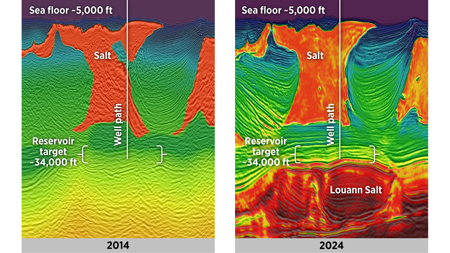
The left image shows the seismic imaging available in 2014, when the first Anchor exploration well was drilled. The reservoir is 34,000 feet deep. The right image shows improved seismic imagery of the same area taken in 2024 with full waveform inversion (FWI) velocity overlay. This technology was used when drilling the Anchor production well. This cross-section image through the earth reveals the sea floor, approximately one mile below the surface. It highlights the big anchor-shaped orange body that is salt, down to the reservoir target that sits above another salt body (the Louann Salt).
Extended FWI breaks the seismic wave field—the ambient noise or motion of the subsurface—down into a series of mathematical instructions, or algorithms. These algorithms are trying to match the wave field data to what is known about the geology of the subsurface in a specific area. Researchers can use this data to get a clearer picture or to reconfigure the information if something doesn’t line up with what is already known about the expanse.
why it matters
With a clearer picture of the subsurface, researchers can characterize the subsurface more accurately. Davenport predicts that in the future, FWI will be assisted by artificial intelligence, resulting in improved 3D images of the subsurface and additional time savings.
topics covered


related content
-

 bayou bend project aims to advance carbon dioxide storage along the US gulf coast
our operationsjune 30, 2025
-
 understanding the pascagoula refinery’s role in US energy independence
our operationsjune 24, 2025
-
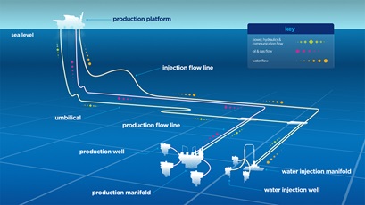
 explainer: what is a tieback?
our operationsmay 15, 2025
-

 getting real about the energy future—in a world where 750 million people still lack electricity
our operationsmay 13, 2025
chevron email updates
Subscribe to our newsletter to receive news and updates.